
 Welcome to Eleuthera - Isle of Freedom
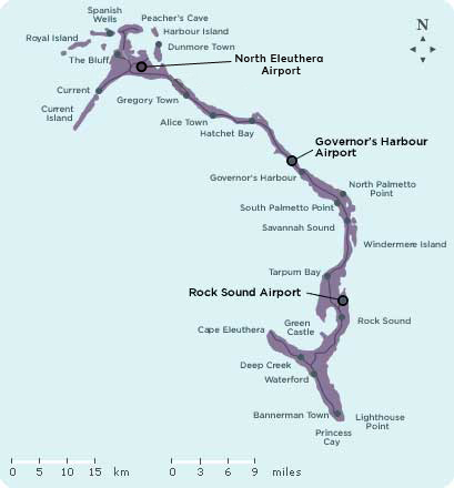
At 110 miles long and a mere two miles wide, Eleuthera effortlessly keeps travelers near its pink-and white-sand beaches, ranging from secluded coves to endless stretches along the coastline. Together with Harbour Island and Spanish Wells, Eleuthera charms travelers with colonial villages and pineapple fields. Eleuthera More than 300 years ago, English Adventurers in search of religious freedom founded the western world’s first true seat of democracy and named it Eleuthera, the Greek word for freedom. Its settlers, fleeing persecution in Bermuda and England, called themselves "The Eleutheran Adventurers” and time and circumstances would prove that tag more accurate than they ever expected. Led by Captain William Sayle, the 70-member band of adventurers first went ashore near Governor’s Harbour. Disputes arose among the group and Sayle and his faction headed off toward the northern part of the island by boat. Their boat floundered on the treacherous reefs and their supplies were lost. Many of them nearly starved, but they made do, living and worshipping in a cavern that is now known as Preacher’s Cave.
Spanish Wells
Spanish Wells was first inhabited in 1649 when the Spanish Conquistadors sunk a well there to provide their ships with potable water. The island was designated the final landing point for their galleons before attempting the arduous journey back to their homeland, loaded down with the riches of the New World. In 1776 the island was settled by some of the Loyalists who came from the Carolinas and many of today’s residents proudly claim that their heritage goes back to those early pioneers. The residents are very industrious and for centuries they have been making their living from the bounty in the miles of deep blue sea around the island. In fact, this small community provides 75% of all the crawfish caught in The Bahamas during the season. They also make excellent fishing guides and diving instructors. Those who are not employed in the fishing industry are involved in farming.
Harbour Island
Called "Briland" by residents, Harbour Island rests off the northeast shoulder of Eleuthera. Only 1.5 square miles in size, Briland is accessible by water taxi or private boat only. The island is home to Dunmore Town, one of the quaintest, prettiest little communities in the country. Brightly painted homes shine in a subdued rainbow of subtle pastel hues. In the morning, the rising sun breaks the surface of the ocean, glinting red off the gleaming surface of the island’s famous pink sand beach. Meander down the quiet, seaside lanes and admire the Victorian filigrees decorating the homes. Watch as fishermen pull their boats up onto the sloping shore. Enjoy the profusion of aromatic, flowering bushes lining the streets. Harbour Island presents a gentle, slightly reserved, but welcoming air that permits solitary wanderings or warm conversation. It’s your choice.
Harbour Island was a noted shipyard and sugar refinement center in the late 1800s, and the resourceful residents have also made their way in the world as skilled shipbuilders and farmers. The island itself has little fertile soil, but residents were given land to farm on the “mainland” (Eleuthera) in 1783, and much of that original grant is still being tilled by Brilanders today. Shipbuilding and farming of citrus, pineapples and tomatoes made Harbour Island fairly prosperous until World War I. The first regular tourist business, which provides the bulk of the island’s livelihood today, began in 1941 with weekly flights on Bahamasair’s predecessor, Bahamas Airways.
-
Pink Sands Beach: Famous Pink Sands Beach is located on the Atlantic Ocean side of Harbour Island. As for the beautiful pink hue, that comes from a simple single-celled animal called a foraminifera or foram for short. There are some 4,000 species of forams, and a few grow bright red shells. Pick up a handful of sand on most Out Island beaches and chances are you’ll be able to find something that looks like the smallest strawberry ever grown: that’s a red foram. Beaches that are fortunate enough to have a large population of these growing offshore, and just the right currents, will wind up with bits of red shell mixed in with its white sand. Put enough red into the white and, voila, you get pink. Horseback riding on Pink Sands Beach is a popular activity for honeymooners.
Roundheads: A hidden overgrown 17th century battery built by the English to defend the island can be found at the southern end of Bay Street. Cannons, called Roundheads, can still be seen at this site.
Loyalist Cottage: For a little bit of history, visit Loyalist Cottage, a wonderful example of loyalist architecture, Commissioner’s Residence built in 1913, St. John’s Anglican Church built in 1768, as well as the Chapel Street cemetery containing ancient graves.
Lone Tree: If you’re interested in mysteries, you should visit the Lone Tree. Some say it was once an almond tree, while others say it’s a species of pine. Regardless, everyone seems to agree that it arrived in Harbour Island after Hurricane Andrew in 1992. How it arrived is up for debate though. Some say it slid down a nearby hill while others say it was blown over from a nearby island. Curiously enough, the tree arrived upright and during high tides, it even moves around a bit.
Eleuthera Attractions
-
Glass Window Bridge: About two miles east of Upper Bogue and north of Gregory Town at the narrowest part of Eleuthera Island, which is just 30 feet wide, is the Glass Window Bridge. Striking rock formations make up the Glass Window Bridge. The land here is high on either side and abruptly falls away to nearly sea level almost dividing the island in two. You can stand in one spot and see the gray Atlantic Ocean to the west and Exuma Sound to the east.
The Cow & The Bull: Another interesting land formation on Eleuthera Island is The Cow & The Bull about a mile south of the Glass Window Bridge. There are two large boulders, on one side, the boulder looks like a bull with two cows and on the other side, a bull with one cow. Both sets of boulders overlook the sea on both side, and when the weather is inclement and the wind passes through, the result is a roar that sounds like bulls.
Preachers Cave : Preachers Cave is a large unique cave about two miles east of Gene’s Bay. Founders who landed and were sheltered here made an altar and held vigils in the cave, giving it its namesake.
Surfer’s Beach: If riding waves is your bag, then bring your gear and head out to Surfer’s Beach, just two miles south of Gregory Town, where southwest winds blow breaks in from the Atlantic. Even if you just want to watch, the two-mile beach has some of the best sugary-soft white sand in The Bahamas.
Hatchet Bay Cave: Just south of Surfer’s Beach is Hatchet Bay Cave. The cave is a mile long and filled with stalagmites and stalactites, which will take on the appearance of underground cathedrals in your torch light. Centuries-old graffiti of charcoal signatures line the walls. It’s recommended to tour with a cave guide.
James Cistern Beach: The waves at James Cistern Beach sometimes reach 10 feet due to a brisk southerly wind making this another great surfing site at Eleuthera. There is also a shipwreck just off shore, great for snorkeling when the water is calm.
Ocean Hole: People often sought out the healing powers of Ocean Hole, rumored to be a bottomless, natural limestone wonder on the south edge of Rock Sound in Eleuthera. Filled with tropical fish and turtles that greet visitors, the brackish water is said to have medicinal purposes. Partake at your own risk.
Lighthouse Beach: One of the best beaches in Eleuthera, some say even better than Pink Sands, is a hidden gem called Lighthouse Beach. Located on the Atlantic side of Eleuthera Point behind some sand dunes is a fantastic secluded blush rose sand beach. With great snorkeling just a walk off the beach, it is a great place to pack a picnic basket and spend an entire romantic afternoon or sunset stroll with your better half.
Eleuthera Beaches
Everyone’s list of the world’s top 10 beaches includes Harbour Island’s famed Pink Sands Beach. Fewer know that pink sand also spreads along the coast of Eleuthera, blessing it with several blushing beaches, most notably French Leave Beach and Winding Bay Beach.
-
Pink Sands Beach Harbour Island is most renowned for its pale pink sand beaches some three plus miles long and 50 to 100 feet wide -considered one of the very best beaches in The Islands Of The Bahamas. The island's beach was featured in The Travel Channel's “World's Best Beaches” segment in March 2005. Named “Best Sand Beach,” Harbour Island was one of 10 beaches worldwide to be included in this program.
Cape Eleuthera Resort Beach : Located on a 4,500-acre private, secluded beach preserve on the tip of southwest Eleuthera, Cape Eleuthera is surrounded by uninhabited wilderness.
The Beach at Pineapple Fields : Located near Governor’s Harbour the beach at Pineapple Fields offers spectacular views and Tippy’s, a one-of-a-kind restaurant and beach bar that one can sit, have a Kalik or lemonade and take in the awesome view.
James Cistern Beach : The waves sometimes reach 10 feet due to a brisk southerly wind making this a great surfing site. Shipwrecks are just off shore and this beach is great for snorkeling when the water is calm.
The Cove Eleuthera Beach : Just up the road from Gregory Town and a stone’s throw from Surfer’s Beach, The Cove Eleuthera offers its guests a private beach amid stunning views from the cliffs of the cove.
Cotton Bay Estates & Villas : Located five miles south of Rock Sound in South Eleuthera are two private beaches of powdery pearl-white sand that stretch for over a mile at this new resort community.
Preacher’s Beach: This beach is located minutes from North Eleuthera. Wind your way down a sandy grassy path overgrown with sea grapes to find a favorite picnic spot after exploring Preachers Cave, one of North Eleuthera’s best known landmarks. The color of the water from this spot is heavenly.
French Leave Beach: One of the handfuls of pink sand beaches on Eleuthera, beautiful French Leave Beach is located just outside of Governor’s Harbour.
Lighthouse Beach: This beach is located in South Eleuthera near Cape Eleuthera and is known for its miles of unspoiled pink, soft, sandy beaches, as well as an old lighthouse located on a dramatic limestone promontory overlooking the ocean.
Surfer's Beach: This beach is located two miles from Gregory Town. The hang-ten set also knows Eleuthera is a hot wave-riding destination, with Surfer’s Beach drawing sun-bleached guys and gals to its island break.
Ten Bay Beach This beach is located nine miles south of Governor’s Harbour in Savannah Sound. It is naturally shaded by large casuarina trees in the morning, but a sun lover’s paradise on a warm Bahamian afternoon.
Diving in Eleuthera
Diving in Eleuthera/Harbour Island.
Not only is it naturally beautiful, it has the most natural wrecks. Home of the first republic in the “New World,” there are more natural wrecks here than any other island. The Devil’s Backbone is a shallow and jagged reef extending across the northern edge of Eleuthera. This reef has torn the bottom out of more vessels than any other reef in the nation. And don’t forget to swim-through the rip-roaring drift dive called Current Cut at Eleuthera.
Shipwrecks in Eleuthera Also known as the Egg Island Wreck, the Arimoroa was a 260-foot freighter that ran aground in 1970 after catching fire. The wreck still sticks above the surface, but vast schools of fish gather around its hull in shallow water.
Top Diving Sites on Eleuthera
-
Devil’s Backbone: Dozens of shipwrecks, including three wrecks layered upon each other
Plateau: 45-100ft. Rolling coral mounds, undercut by ledges
The Arch: A giant arch of coral that forms a nearly concealed grotto Current Cut: Divers ride the current through a marine menagerie of fish and Eagle Rays
The Pinnacles: 100 ft. Dive on a cavernous mountain of coral
Carnavon: This intact 200-foot freighter sank in 1919
Eleuthera/Harbour Island Diving Sites Key: R=Reef; C=Cave; W=Wreck; L=Wall; M=Unusual marine life
35' W Carnavon - This intact 200-foot freighter sank in 1919
M-Current Cut - Divers ride the current through a marine menagerie of fish and Eagle Rays
20' W-Devil's Backbone - Dozens of shipwrecks, including three wrecks layered upon each other
45-100' W Plateau - Rolling coral mounds, undercut by ledges The Arch A giant arch of coral that forms a nearly concealed grotto
100'+ The Pinnacles - Dive on a cavernous mountain of coral
50-130' R The Cage - Situated right on the wall, this open water aquaculture cage was planted by the Island School and used as resarch for the school's marine biology program.
40-130' L Hole in the Wall - A large swim-through tunnel into the deep blue of the Sound. Take time to explore the sponge-laden vertical face of the coral wall
20-50' M Tunnel's Rock - A great cavern cutting through the primary coral head in a broad reef field
Snorkeling in Eleuthera
Eleuthera
Only a mile wide over most of it’s 112-mile length, Eleuthera embodies an odd assortment of qualities. Quiet, isolated communities and well-developed resorts, fishing and farming, tall rock bluffs and low-lying wetlands, blue holes and caves, massive coral reefs and sweeping pink sand beaches combine to create a fascinating picture. Eleuthera was first settled in the 1600s by Bermudians seeking religious freedom (the Greek word eleutheria means freedom). The only problem was, before they found the island itself, they found the Devil’s Backbone an extensive shallow reef line bordering the north end of the island. It ripped open the bottom of their boats leaving them to settle amongst the sharp coral heads. Today’s visitors will have an entirely different experience with the Backbone as well as with the many other coral reefs skirting the island’s long coastline. Forests of elkhorn corals interspersed with star and brain corals are crowned by slowly waving sea fans. Watch lobsters poke their antenna out from holes as eels wind their way through the reef. The Devil’s Backbone still holds remnants of ill-fated, unfortunate ships—anchors, boilers, plating—and even an old train awaiting your discovery and exploration.
The Devil’s Backbone: A ridge of barely submerged coral reefs stretching across the northern edge of Harbour Island and Eleuthera, has been the final resting place for dozens of vessels over the years. Today, that same area of sorrow is a place of joy for snorkelers exploring the waters. Enjoy a sense of history mingled with an appreciation of the marine world as fish mill around ancient anchors embedded in the coral
Eleuthera
As you can see Eleuthera has a lot to offer. From Spanish Wells and Harbour Island in the north all the way south to Cape Eleuthera there is a lot to see and do. Not only will you enjoy the view of the ocean and the feel of the powder soft sand between your toes but more importantly you will enjoy the warm and gracious hospitality of the people who live here.
Russell Island


Spanish Wells


